Applied Technology to Address Social Emergencies
30/11/2017
The Regional Fund for Digital Innovation in Latin America and the Caribbean (FRIDA) has provided financial support to Mapeo Digital (Digital Mapping), a project aimed at developing a methodology that will allow identifying risk factors and at-risk areas in settlements in the Guatemala City metropolitan area.
The grant awarded by FRIDA served to boost this initiative which seeks to help streamline and prioritize public policies in these territories.
According to project leaders Onice Arango and Andrea Valladares, this technological project for the participatory mapping of social and territorial risks seeks to become a benchmark for multisectoral participation in the generation of urban information and diagnosis.
What does the project for the digital mapping of settlements in Guatemala City consist of and how did the initiative come about?
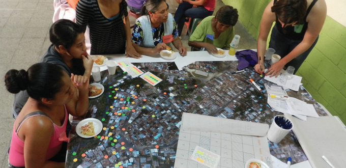
Mapeo Digital is a project for the participatory mapping of social and territorial risks in vulnerable areas. It is promoted by Perpendicular (https://www.perpendiculargt.com/), an initiative we co-founded to conduct research and implement actions that will achieve solutions to urban issues in collaboration with different actors. We thought of this idea after a landslide caused the death of 266 people in a community vulnerable to landslides.
The proposal focuses on two fronts. The first is institutional and seeks to promote meeting spaces that will strengthen networking among the different actors and validating the integration of the project within the Guatemalan context. The second is a community front: through a series of participatory workshops and the use of technology, we try to identify at-risk areas in each territory by mapping the collective knowledge of the population, while the population itself receives training to identify these risks.
How do you use an app to collect data with drones and georeferencing?
Information is collected and georeferenced at different stages of the process. The first of these stages is during the flight of the drone, this allows us to generate an updated photograph of the community with which we later work during the community mapping stages.
We also use the Co-Mapp (http://co-mapp.org/) app developed by the Mexican Observatory of the Right to Housing to conduct a socio-economic survey of each household. This application allows us to georeference the place where the survey is conducted and to link the data with the photo of the settlement using Quantum GIS software.
How did you manage to engage the community in surveying and mapping their territory?
We formed different alliances with strategic players, one of which was TECHO Guatemala. Their ties with the community allowed us to meet with community leaders, present the goals of the project and determine their interest in participating in the digital mapping of their communities, and the chance to support us during the implementation phase. A community assembly was then summoned to provide information on the project, describe its various stages, and establish a timeline.
What type of data were you able to collect regarding the risk of each settlement after completing the first mappings in the area under study?
The mapping allowed us to obtain qualitative and quantitative data from four different communities. Qualitative data consists of information on existing infrastructure within the community and surrounding areas, a list of primary threats to the community and housing, the number of inhabitants and how they are affected, their ability to respond to a threat, and potentially feasible projects at community level to reduce their vulnerability.
Quantitative data focuses more on the collection of household data including income, health services, education, housing, social security, and basic services, which allow for a multidimensional assessment of poverty. In addition, a tool designed for the metropolitan area was applied in selected households to determine their susceptibility and risk exposure to minor landslides.
This information is being shared with different public institutions and organizations so they will affect decision-making and actions, exploring their value and the importance of continuing their collection.
What results have you achieved since receiving funding from FRIDA?
In one year we were able to map four vulnerable communities and actively involve 220 people in these processes. We’ve also managed to socialize the methodology, sharing it with more than 30 public, private and third-sector institutions and organizations, and strengthen our alliances with key players for the project’s sustainability.
Thanks to the experience we acquired and our synergy with different actors, we co-organized the First Meeting of Urban Resilience of the Metropolitan Area, which kicked off a discussion among different sectors on actions for intervening in informal settlements and their limitations.
Perpendicular has positioned itself as an initiative for social innovation in matters of resilience, while other research and action opportunities continue to arise in vulnerable areas.